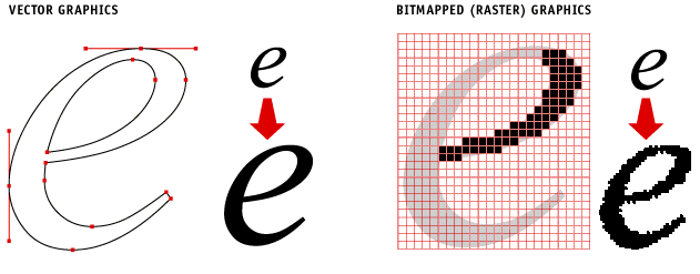
In the world of cartographic data, a very large number of different file formats are used. These formats can be classified into two fundamental forms of digital representation:
- bitmapped: raster graphics
- vectorial: vector graphics

btxprojectcomputergraphics
Raster graphics
- These are images (scanned maps, aerial photographs, satellite images, digital elevation models) that are spatially represented. The data is composed of a set of pixels.
The best known and more commonly used formats are:- ASC: text file in ascii format
- ECW: Enhanced Compression Wavelet, digital image compression format owned by ERMapper
- JP2: image compression format with or without loss
- TIFF: image in raster format which can include numerous alphanumeric attributes. When these attributes contain georeferencing information, the format is referred to as GeoTIFF
- XYZ: XYZ files are simple ASCII files which can be opened with any standard text editor. They are composed of a series of X, Y and Z coordinates, separated by a semi-colon, comma or space
- NETCDF
Vector graphics
Vector graphics are based on geometric objects (points, lines, polygons) to represent geographical entities.
The best known and more commonly used formats are:
- KML/KMZ: File extension used by Google, in particular Google Earth in XML format. It became an OGC (Open Geospatial Consortium) standard in 2008
- Shapefile: proprietary format developed by ESRI and which is the reference today in terms of vector data. It is associated with other extensions such as .shx, .dbf, .sbn, .prj
- GML: Geographic Markup Language, based on XML, is recongised as a standard by OGC (Open Geospatial Consortium)
MAP/TAB: format connected with MapInfo software
Sources :
https://georezo.net/wiki/main/donnees/extensions
https://www.emse.fr/tice/uved/SIG/Glossaire/co/Format_1.html
http://www.ente-aix.fr/documents/118-demoGeo/demo/4_BasesIG/co/20_gr_PubliRasterVecteur.html
