Observation sources
Oceanographic vessels
The instruments deployed from oceanographic vessels gather data relating to the water column, seabed and sub-bottom in the following fields:
- Meteorology
- Physics (Temperature, Salinity, Currents, etc.)
- Geophysics (Gravimetry, Magnetism, Bathymetry, Acoustic imagery, Seismics)
- Geological sampling and biological sampling (benthos)
- Fishery resources
For more information see the Ifremer fleet website and the French oceanographic fleet website.
Underwater vehicles
Underwater vehicles, whether manned or autonomous, are used to gather very high precision data close to the seafloor. These data relate to geophysics, biology and biogeochemistry.
More information on the following websites: the Ifremer fleet, the Ifremer Underwater Systems Unit, the European Underwater Technology Centre (CETSM),"A la découverte des grands fonds", Les Nouvelles de l'Ifremer - Technologies sous-marines (octobre 2009).
Les Nouvelles de l'Ifremer - Technologies sous-marines (octobre 2009)
Argo floats
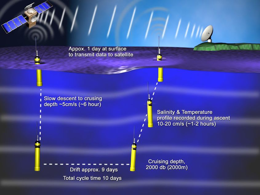
Drifter buoys and floats are an essential source of in situ ocean data. They are used to record specific parameters (temperature, salinity, etc.) from the surface down to depths of 2,000 m according to the model.
The Argo array for instance comprises over 3,900 free-drifting floats across all the world's oceans. These floats drift below the ocean surface for several days to take measurements then come up to the surface to transmit the information by satellite.
Learn more about the Argo programme.

©Ifremer
Human observation networks
Human observation networks provide the data required to monitor the shoreline and the coastal zone, in a bid to gain a fuller understanding of the oceans and to ensure sustainable resource management.
For more information see the shoreline environment website. Find out about the Rebent network, which monitors the biodiversity of flora and fauna in coastal benthic areas.
Ifremer
Sea professionals and scientific investigators

©Ifremer
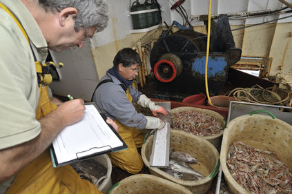
Sea professionals and scientific investigators provide information particularly on fishing activities. Ifremer's Fisheries Information System (SIH) for instance is based on close ties with the French Directorate of Sea Fisheries and Aquaculture (DPMA) and fishing professionals to obtain field data.
For more information see the SIH website and "Pour une pêche durable".
Citizens
Through participatory science projects, citizens can contribute to achieving a fuller understanding of marine biodiversity. The Phenomer project for example focuses on the biodiversity of microalgae: through this programme, scientists establish a data-gathering protocol and citizens then make observations and take samples.
All the data collected are then used to analyse resources and their environment: water pollution, habitat destruction, climate change, resource use levels, etc.
One example of a participatory science project: the game Deep Sea Spy.
An other example of a participatory science project: Phenomer.
Animals
To add to existing oceanographic data (from autonomous profilers, oceanographic vessels, etc.), the profiles gathered thanks to sea elephants in the Southern Ocean improve scientists' knowledge of the components of the Antarctic Circumpolar Current, the world's most powerful current.
See two articles on elephant seals:
- "Pour mieux comprendre la circulation océanique, les éléphants de mer apportent de nouvelles données sur les eaux Antarctiques" (CNRS).
- "Argos – Tracking elephant seals to understand the Southern Ocean" (CNES)
Satellites
Satellites are used to gather information on the ocean's surface, such as temperature, salinity, water level and waves.
For more information see the Cersat and CATDS websites.
Airborne platforms
Airborne platforms provide aerial photographs and altimetric and hyperspectral images of the oceans. For instance, historical aerial photographs of the coastline can be used to identify changes in coastal areas by overlaying them with more recent data. They provide information related to issues such as urbanisation, erosion and the impact of anthropogenic activities.
Example of the website of historical aerial photographs of the coastline.
