What is a web service?
Websites or applications are constructed from code which is sent by servers to web browsers (Firefox, Chrome, etc.). The web browser interprets this code and executes it using hardware resources (processor, memory, etc.,) on the client workstation.
The content (data, such as observation positions or metadata such as the description of datasets) presented and processed by these web applications is accessed when the web pages load or according to the actions of the user. This content is sent over the Internet by web services.
Example:
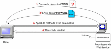
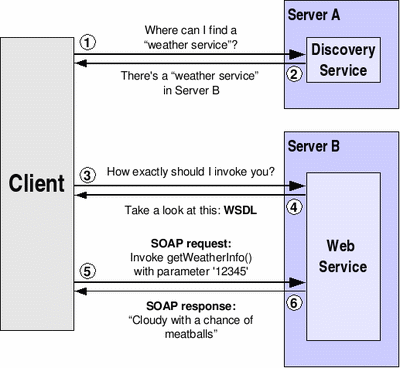
The use of a web service may be divided into different stages:
- In stage 1, the client asks the service how to invoke it (i.e. how to request a service). The web service is asked for its WSDL (Web Service Description Language) contract: this is a formalised document (XML, W3C) which specifies the methods that may be called by this web service.
- In stage 2, the service returns its description (WSDL) indicating how to invoke this service (methods, format of calls, parameters, values returned, etc.). Upon use: we call the method (SOAP+XML) that is desired in accordance with the previously acquired format. This is done quite simply by instantiating and using its methods. This is a transparent process.
- In stage 3, the client invokes the service by sending a SOAP request in accordance with the previously acquired format.
- In stage 4, the service returns the response to the client in a reply (still in SOAP). We recover the result of the method.
Points in common between the various web services
All web services have common points:
- WEB services HTTP(POST/GET)
- Common parameters: SERVICE, VERSION, REQUEST, etc.
- Self-description of services provided: REQUEST=GetCapabilities
- Format XML (Output format of the text reply: always XML)
- Coordinate Reference Systems (CRS or SRS): EPSG codification (complete list: http://www.epsg-registry.org)
What content?
The access portals to marine information enable the following content to be explored:
- the descriptions of:
- means of observation and analysis of the marine environment
- observations carried out
- data products assembled for users
- services for the conversion and processing of data
- scientific publications
- persons and organisations contributing to the observation and analysis of the marine environment.
- vocabularies and reference terms used in the content
- data from:
- results of observations
- compilations of results of observations or summaries
Why standardise web services?
There are two reasons why we standardise web services which transmit this content.
The first is that the structure of the content (description of the means of observation, results of observation, etc.,) is more stable than the way in which we present it in web pages. Therefore, the same web service transmitting content may be presented in different ways for different projects, in different contexts according to the requirements of users without it being necessary to redevelop the software that supplies the web services and transmits the content.
The second is that content may be shared with partner sites. The use of standards for querying and transmitting content facilitates its use by partner sites.
What standards for which content?
Amongst the standards, we sometimes distinguish:• protocols: they define the procedures for querying web services, for example: "I want the results of temperature observations in the water column in the Mediterranean".• formats: they define the structure of the replies and content sent by web services, for example CSV.The standards are developed by various organisations (OGC, W3C, ISO, OAI, WebID, etc.).For geo-referenced content, the Open GIS Consortium protocols are used:General protocols:
Content |
Protocol |
Format |
Distribution of dynamic maps (images of geographical maps) |
OGC/WMS |
png, tiff, jpeg, ... |
Distribution of geographical components ("features"): distribution of geo-referenced entities (locations, limits, trajectories,…) |
OGC/WFS |
GML |
Distribution of geographical coverage |
OGC/WCS |
|
Distribution of data and metadata from observation equipment (sensors) |
OGC/SOS |
|
Querying of catalogues of metadata |
OGC/CSW |
Dedicated protocols:
Content |
Protocol |
Format |
Description of observation equipment and analysis methods |
OGC/SOS |
SensorML |
Description of observations |
OGC/SOS |
O&M |
Résultat des observations |
||
|
OGC/WFS |
GML |
|
OGC/SOS |
GML, JSON, netCDF, CSV |
Description of assembled data products |
OGC/CSW |
ISO19139, Dublin-Core |
Results of data products |
||
|
OGC/SOS |
NetCDF, CSV |
|
OGC/WCS |
NetCDF, CSV |
Data conversion and processing services |
OGC/WPS |
any |
For non-geo-referenced content, specific standards are used:
Content |
Standard |
Description of publications |
OAI-PMH, OAI-ORE |
Description of persons |
WebID/FOAF |
Vocabularies and reference terms |
W3C / SPARQL, SKOS, OWL, RDF, ... |
Dedicated community standards are also used to transmit certain observation or analysis results:
Content |
Standard |
Physics and bio-geo-chemistry of the ocean and the atmosphere |
OPENDAP |
Biodiversity |
Darwin-Core |
Lastly, dynamic web applications, which have been developed since the 2000s under the name of AJAX or Web 2.0, make intensive use of web services called RESTful. These services implement the web logic (resources containing links to other resources) to access content. The format of this content is usually JSON. These web services are also standardised to access marine information, like the SensorThings API proposed by the OGC.


